I don't want to use GPS on the bike. I have enough trouble paying attention to the road. I do have a compass and pretty good sense of direction. If I am going somewhere new, I spend a fair amount of time with google maps looking for good roads that hopefully avoid too many long slow traffic laden stretches. I live in NJ about 10 miles from the GWB so this is not always easy. The country side isn't too far way though. Does anyone have a good method for finding the best-for-you way to get where you're going. I don't really mind getting lost for a while and asking directions. That sounds so old-fashioned. I really hate getting stuck in endless traffic though. Too many stop lights etc. Maybe there is a Goldilocks maps service for those who want the perfect thing that is not the highway and not a 25mph zone. I do need to invest in some easy to carry maps.
Navigation
Install the app
How to install the app on iOS
Follow along with the video below to see how to install our site as a web app on your home screen.
Note: This feature may not be available in some browsers.
More options
Style variation

You are using an out of date browser. It may not display this or other websites correctly.
You should upgrade or use an alternative browser.
You should upgrade or use an alternative browser.
Trip planning tools
- Thread starter Tom_imp
- Start date
LongRanger_imp
Road warrior
I’m not sure about your area, but Butler Maps are designed for exactly what you’re looking for. Otherwise, you may want to search for some “Best of NJ / Mid-Atlantic” motorcycle guide books. I too despise GPS for trip planning.
Edit: Butler just came out with a “Northern Mid-Atlantic” map, featuring routes in NJ, PA, and southern NY.
Edit: Butler just came out with a “Northern Mid-Atlantic” map, featuring routes in NJ, PA, and southern NY.

Stichill
Road warrior
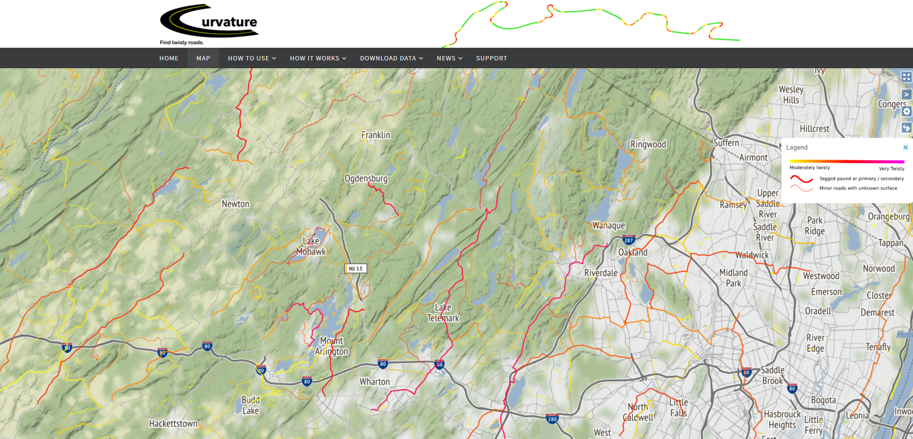

rboe
Road warrior
I picked up the new Garmin GPS for bikes. Not that impressed.
However; I discovered my new phone will talk to me via my Cardo headset which worked out pretty good on my last trip. Now the GPS can do the same thing so you don't have to look at it.
I used to put a paper map in a clear top pocket on the tank bag but I find a GPS is actually safer (easier to read and closer to my line of sight).
In any event, I use paper maps and google maps to pre-plan a trip - and found google map routes can be (with a 3rd party) can be sent to the Garmin via Bootcamp (a software package I'm not keen on). Butler maps are really useful if you ride dirt and dual sports.
However; I discovered my new phone will talk to me via my Cardo headset which worked out pretty good on my last trip. Now the GPS can do the same thing so you don't have to look at it.
I used to put a paper map in a clear top pocket on the tank bag but I find a GPS is actually safer (easier to read and closer to my line of sight).
In any event, I use paper maps and google maps to pre-plan a trip - and found google map routes can be (with a 3rd party) can be sent to the Garmin via Bootcamp (a software package I'm not keen on). Butler maps are really useful if you ride dirt and dual sports.
Stichill
Road warrior
GPS technology is horrible! In 2021 there is no excuse for how arcane and technologically backward it is. Garmin & TomTom are equally bad. TomTom used to be "pretty good" with the My Routes route planning app on your phone that you could shoot to the GPS by Bluetooth in seconds...then they intentionally broke that. Tyre to Travel was a great route-planning & POI software that could directly load routes and POIs into the TomTom...then they intentionally broke that too. Now they have subscription-ware that they want me to pay for? No way, I have zero trust in these clowns. Now my Rider 400 is just a stupid lump with old maps and rudimentary route-planning abilities.Rboe_imp said:I picked up the new Garmin GPS for bikes. Not that impressed.
However; I discovered my new phone will talk to me via my Cardo headset which worked out pretty good on my last trip. Now the GPS can do the same thing so you don't have to look at it.
I used to put a paper map in a clear top pocket on the tank bag but I find a GPS is actually safer (easier to read and closer to my line of sight).
In any event, I use paper maps and google maps to pre-plan a trip - and found google map routes can be (with a 3rd party) can be sent to the Garmin via Bootcamp (a software package I'm not keen on). Butler maps are really useful if you ride dirt and dual sports.
I always say that Google could drop in and destroy both of these GPS slumlords if they every introduced a Google Maps GPS product line.

Tev62
Road warrior
They already have decimated the market with the amount of people using google maps on their phones albeit with rudimentary routes, no need for them to make dedicated hardware.Stichill_imp said:GPS technology is horrible! In 2021 there is no excuse for how arcane and technologically backward it is. Garmin & TomTom are equally bad. TomTom used to be "pretty good" with the My Routes route planning app on your phone that you could shoot to the GPS by Bluetooth in seconds...then they intentionally broke that. Tyre to Travel was a great route-planning & POI software that could directly load routes and POIs into the TomTom...then they intentionally broke that too. Now they have subscription-ware that they want me to pay for? No way, I have zero trust in these clowns. Now my Rider 400 is just a stupid lump with old maps and rudimentary route-planning abilities.Rboe_imp said:I picked up the new Garmin GPS for bikes. Not that impressed.
However; I discovered my new phone will talk to me via my Cardo headset which worked out pretty good on my last trip. Now the GPS can do the same thing so you don't have to look at it.
I used to put a paper map in a clear top pocket on the tank bag but I find a GPS is actually safer (easier to read and closer to my line of sight).
In any event, I use paper maps and google maps to pre-plan a trip - and found google map routes can be (with a 3rd party) can be sent to the Garmin via Bootcamp (a software package I'm not keen on). Butler maps are really useful if you ride dirt and dual sports.
I always say that Google could drop in and destroy both of these GPS slumlords if they every introduced a Google Maps GPS product line.
I still like to use my Tom Tom for multi day trips planned with MyRouteApp. You can save the output wirelessly to your Tom Tom automatically which is handy. That gives you a Track, if you want a Route you do have to save the output from MyRouteApp as an ITN file and transfer to the Tom Tom, either connected to the PC or via an SD card. I find MyRouteApp (even the free functionality) very useful for trip planning even if you don't use the GPX output on a device. Just planning how far or how many hours a day you want to ride is handy.
GoldOxide_imp
Road warrior
I can't remember the last time I used a dedicated GPS unit - and it was a Tom Tom brand. It was good at what it did at the time, but Google Maps and similar off-line available apps have worked well for me for so many years now that I cannot remember how many.
In any case, one less electronic thing to fuss with, to power/charge, and the mobile phones (old and current) I have are already waterproof and ready to go in a pinch.
In any case, one less electronic thing to fuss with, to power/charge, and the mobile phones (old and current) I have are already waterproof and ready to go in a pinch.
rboe
Road warrior
I tend to use mine (mainly in the truck) to see how far it is to the next stop. That way if I need to pee or eat or get gas I can noodle out if I need to do so earlier. 
And they can be really useful for getting through Kansas City.
And they can be really useful for getting through Kansas City.
I just plan my trips with Google maps ahead of time and then either print or write out deviations (other roads, museums, points of interest). One feature I particularly like is the gas station locations along the routes. In addition, I have my laptop with me with Microsoft maps for brushing up on my course from the motel room. This works for me.
Stichill
Road warrior
They broke all of that stuff for me with my Rider 400: MyRouteApp will pair with TomTom but will not communicate. Data can bread read from the TomTom but not sent to it over USB. I also don't understand why they launch and then discontinue different names for the various services.Tev62_imp said:They already have decimated the market with the amount of people using google maps on their phones albeit with rudimentary routes, no need for them to make dedicated hardware.Stichill_imp said:GPS technology is horrible! In 2021 there is no excuse for how arcane and technologically backward it is. Garmin & TomTom are equally bad. TomTom used to be "pretty good" with the My Routes route planning app on your phone that you could shoot to the GPS by Bluetooth in seconds...then they intentionally broke that. Tyre to Travel was a great route-planning & POI software that could directly load routes and POIs into the TomTom...then they intentionally broke that too. Now they have subscription-ware that they want me to pay for? No way, I have zero trust in these clowns. Now my Rider 400 is just a stupid lump with old maps and rudimentary route-planning abilities.Rboe_imp said:I picked up the new Garmin GPS for bikes. Not that impressed.
However; I discovered my new phone will talk to me via my Cardo headset which worked out pretty good on my last trip. Now the GPS can do the same thing so you don't have to look at it.
I used to put a paper map in a clear top pocket on the tank bag but I find a GPS is actually safer (easier to read and closer to my line of sight).
In any event, I use paper maps and google maps to pre-plan a trip - and found google map routes can be (with a 3rd party) can be sent to the Garmin via Bootcamp (a software package I'm not keen on). Butler maps are really useful if you ride dirt and dual sports.
I always say that Google could drop in and destroy both of these GPS slumlords if they every introduced a Google Maps GPS product line.
I still like to use my Tom Tom for multi day trips planned with MyRouteApp. You can save the output wirelessly to your Tom Tom automatically which is handy. That gives you a Track, if you want a Route you do have to save the output from MyRouteApp as an ITN file and transfer to the Tom Tom, either connected to the PC or via an SD card. I find MyRouteApp (even the free functionality) very useful for trip planning even if you don't use the GPX output on a device. Just planning how far or how many hours a day you want to ride is handy.
I hadn't thought of the SD card method. Cumbersome but may be feasible.

emptysea
Road warrior
Tom, the original poster, likes maps and memory. I can't say as I disagree with that approach much, especially when riding solo. Others have opined about their approaches to route planning and all seem valid to me, not that my opinion is worth the time it takes to read it.
For me, since I usually ride with at least one other person and since we usually have a specific destination in mind, I prefer to plan the route in advance. I use Google Maps on my desktop and then export that route into Scenic and use my phone to view my route. I do not use the audio turn-by-turn in Scenic and I do often have a paper back-up in case my phone craps out plus I do a "dry run" on new routes, including identifying gas and food stops along with landmarks on Google Maps before the ride. I can share the route with the other riders in my group so they know where I'm heading which is a nice feature. Most of this I've done because I don't want a tank bag mucking up the looks of our beautiful motorcycle. LOL So basically, I've gone hi-tech out of pure vanity.
For me, since I usually ride with at least one other person and since we usually have a specific destination in mind, I prefer to plan the route in advance. I use Google Maps on my desktop and then export that route into Scenic and use my phone to view my route. I do not use the audio turn-by-turn in Scenic and I do often have a paper back-up in case my phone craps out plus I do a "dry run" on new routes, including identifying gas and food stops along with landmarks on Google Maps before the ride. I can share the route with the other riders in my group so they know where I'm heading which is a nice feature. Most of this I've done because I don't want a tank bag mucking up the looks of our beautiful motorcycle. LOL So basically, I've gone hi-tech out of pure vanity.
KiowaEagle_imp
Road warrior
I have played around extensively to find a good route planning/gps solution. Scenic is great for planning routes. It consistently finds good roads and I've been very happy with it. But I don't like using my iphone as a gps. Plus in the heat of summer it overheats in the sun becoming useless or if it rains it's not waterproof. So I'd prefer to use my Garmin but it's navigation is rudimentary at best. If you set it for curvy roads it will take you into a local neighborhood and make you do a bunch of turns, that's it's idea of curvy.
So I started exporting the gpx file from scenic and loading it in to the garmin but ran into an issue, the garmin would overwrite the turn by turn directions basically turning it into a garmin route which sucks. So I've found a solution that seems to work reasonably well. When you export a gpx file it sends three parts, two Trip files and a Track file. Once it's in the garmin go to Tracks and find that track file, then convert it to a trip. Once it's a trip you can load it up and it will follow the scenic route instead of overwriting it as long as you turn off Route Recalculation in the Navigation menu of the garmin.
It sounds more convoluted than it is and it works reasonably well but it's not perfect. If anyone has found a better work around I'd love to hear about it.
So I started exporting the gpx file from scenic and loading it in to the garmin but ran into an issue, the garmin would overwrite the turn by turn directions basically turning it into a garmin route which sucks. So I've found a solution that seems to work reasonably well. When you export a gpx file it sends three parts, two Trip files and a Track file. Once it's in the garmin go to Tracks and find that track file, then convert it to a trip. Once it's a trip you can load it up and it will follow the scenic route instead of overwriting it as long as you turn off Route Recalculation in the Navigation menu of the garmin.
It sounds more convoluted than it is and it works reasonably well but it's not perfect. If anyone has found a better work around I'd love to hear about it.
Stichill
Road warrior
Lol, same!EmptySea_imp said:Tom, the original poster, likes maps and memory. I can't say as I disagree with that approach much, especially when riding solo. Others have opined about their approaches to route planning and all seem valid to me, not that my opinion is worth the time it takes to read it.
For me, since I usually ride with at least one other person and since we usually have a specific destination in mind, I prefer to plan the route in advance. I use Google Maps on my desktop and then export that route into Scenic and use my phone to view my route. I do not use the audio turn-by-turn in Scenic and I do often have a paper back-up in case my phone craps out plus I do a "dry run" on new routes, including identifying gas and food stops along with landmarks on Google Maps before the ride. I can share the route with the other riders in my group so they know where I'm heading which is a nice feature. Most of this I've done because I don't want a tank bag mucking up the looks of our beautiful motorcycle. LOL So basically, I've gone hi-tech out of pure vanity.
Very agree!KiowaEagle_imp said:I have played around extensively to find a good route planning/gps solution. Scenic is great for planning routes. It consistently finds good roads and I've been very happy with it. But I don't like using my iphone as a gps. Plus in the heat of summer it overheats in the sun becoming useless or if it rains it's not waterproof. So I'd prefer to use my Garmin but it's navigation is rudimentary at best. If you set it for curvy roads it will take you into a local neighborhood and make you do a bunch of turns, that's it's idea of curvy.
So I started exporting the gpx file from scenic and loading it in to the garmin but ran into an issue, the garmin would overwrite the turn by turn directions basically turning it into a garmin route which sucks. So I've found a solution that seems to work reasonably well. When you export a gpx file it sends three parts, two Trip files and a Track file. Once it's in the garmin go to Tracks and find that track file, then convert it to a trip. Once it's a trip you can load it up and it will follow the scenic route instead of overwriting it as long as you turn off Route Recalculation in the Navigation menu of the garmin.
It sounds more convoluted than it is and it works reasonably well but it's not perfect. If anyone has found a better work around I'd love to hear about it.
My TomTom is not quite that bad, but it will take you on a short detour from "Main Road" onto 0.2 miles of "Old Main Road" and back out onto "Main Road". :huh:KiowaEagle_imp said:I have played around extensively to find a good route planning/gps solution. Scenic is great for planning routes. It consistently finds good roads and I've been very happy with it. But I don't like using my iphone as a gps. Plus in the heat of summer it overheats in the sun becoming useless or if it rains it's not waterproof. So I'd prefer to use my Garmin but it's navigation is rudimentary at best. If you set it for curvy roads it will take you into a local neighborhood and make you do a bunch of turns, that's it's idea of curvy.
So I started exporting the gpx file from scenic and loading it in to the garmin but ran into an issue, the garmin would overwrite the turn by turn directions basically turning it into a garmin route which sucks. So I've found a solution that seems to work reasonably well. When you export a gpx file it sends three parts, two Trip files and a Track file. Once it's in the garmin go to Tracks and find that track file, then convert it to a trip. Once it's a trip you can load it up and it will follow the scenic route instead of overwriting it as long as you turn off Route Recalculation in the Navigation menu of the garmin.
It sounds more convoluted than it is and it works reasonably well but it's not perfect. If anyone has found a better work around I'd love to hear about it.
This post nails it. We are living through some kind of motorcycle navigation dark ages where you have to submit to the rack or shut yourself into an iron maiden in order to get a decent route loaded into your GPS.KiowaEagle_imp said:I have played around extensively to find a good route planning/gps solution. Scenic is great for planning routes. It consistently finds good roads and I've been very happy with it. But I don't like using my iphone as a gps. Plus in the heat of summer it overheats in the sun becoming useless or if it rains it's not waterproof. So I'd prefer to use my Garmin but it's navigation is rudimentary at best. If you set it for curvy roads it will take you into a local neighborhood and make you do a bunch of turns, that's it's idea of curvy.
So I started exporting the gpx file from scenic and loading it in to the garmin but ran into an issue, the garmin would overwrite the turn by turn directions basically turning it into a garmin route which sucks. So I've found a solution that seems to work reasonably well. When you export a gpx file it sends three parts, two Trip files and a Track file. Once it's in the garmin go to Tracks and find that track file, then convert it to a trip. Once it's a trip you can load it up and it will follow the scenic route instead of overwriting it as long as you turn off Route Recalculation in the Navigation menu of the garmin.
It sounds more convoluted than it is and it works reasonably well but it's not perfect. If anyone has found a better work around I'd love to hear about it.
KiowaEagle_imp
Road warrior
LOL.....I don't know if it's that bad but it's not easy. But I agree that the technology should be much better by now. I don't know why Scenic can get it so right but Garmin can't or why you can't just easily export a Scenic route to use in another device.Stichill_imp said:Lol, same!EmptySea_imp said:Tom, the original poster, likes maps and memory. I can't say as I disagree with that approach much, especially when riding solo. Others have opined about their approaches to route planning and all seem valid to me, not that my opinion is worth the time it takes to read it.
For me, since I usually ride with at least one other person and since we usually have a specific destination in mind, I prefer to plan the route in advance. I use Google Maps on my desktop and then export that route into Scenic and use my phone to view my route. I do not use the audio turn-by-turn in Scenic and I do often have a paper back-up in case my phone craps out plus I do a "dry run" on new routes, including identifying gas and food stops along with landmarks on Google Maps before the ride. I can share the route with the other riders in my group so they know where I'm heading which is a nice feature. Most of this I've done because I don't want a tank bag mucking up the looks of our beautiful motorcycle. LOL So basically, I've gone hi-tech out of pure vanity.
Very agree!KiowaEagle_imp said:I have played around extensively to find a good route planning/gps solution. Scenic is great for planning routes. It consistently finds good roads and I've been very happy with it. But I don't like using my iphone as a gps. Plus in the heat of summer it overheats in the sun becoming useless or if it rains it's not waterproof. So I'd prefer to use my Garmin but it's navigation is rudimentary at best. If you set it for curvy roads it will take you into a local neighborhood and make you do a bunch of turns, that's it's idea of curvy.
So I started exporting the gpx file from scenic and loading it in to the garmin but ran into an issue, the garmin would overwrite the turn by turn directions basically turning it into a garmin route which sucks. So I've found a solution that seems to work reasonably well. When you export a gpx file it sends three parts, two Trip files and a Track file. Once it's in the garmin go to Tracks and find that track file, then convert it to a trip. Once it's a trip you can load it up and it will follow the scenic route instead of overwriting it as long as you turn off Route Recalculation in the Navigation menu of the garmin.
It sounds more convoluted than it is and it works reasonably well but it's not perfect. If anyone has found a better work around I'd love to hear about it.
My TomTom is not quite that bad, but it will take you on a short detour from "Main Road" onto 0.2 miles of "Old Main Road" and back out onto "Main Road". :huh:KiowaEagle_imp said:I have played around extensively to find a good route planning/gps solution. Scenic is great for planning routes. It consistently finds good roads and I've been very happy with it. But I don't like using my iphone as a gps. Plus in the heat of summer it overheats in the sun becoming useless or if it rains it's not waterproof. So I'd prefer to use my Garmin but it's navigation is rudimentary at best. If you set it for curvy roads it will take you into a local neighborhood and make you do a bunch of turns, that's it's idea of curvy.
So I started exporting the gpx file from scenic and loading it in to the garmin but ran into an issue, the garmin would overwrite the turn by turn directions basically turning it into a garmin route which sucks. So I've found a solution that seems to work reasonably well. When you export a gpx file it sends three parts, two Trip files and a Track file. Once it's in the garmin go to Tracks and find that track file, then convert it to a trip. Once it's a trip you can load it up and it will follow the scenic route instead of overwriting it as long as you turn off Route Recalculation in the Navigation menu of the garmin.
It sounds more convoluted than it is and it works reasonably well but it's not perfect. If anyone has found a better work around I'd love to hear about it.
This post nails it. We are living through some kind of motorcycle navigation dark ages where you have to submit to the rack or shut yourself into an iron maiden in order to get a decent route loaded into your GPS.KiowaEagle_imp said:I have played around extensively to find a good route planning/gps solution. Scenic is great for planning routes. It consistently finds good roads and I've been very happy with it. But I don't like using my iphone as a gps. Plus in the heat of summer it overheats in the sun becoming useless or if it rains it's not waterproof. So I'd prefer to use my Garmin but it's navigation is rudimentary at best. If you set it for curvy roads it will take you into a local neighborhood and make you do a bunch of turns, that's it's idea of curvy.
So I started exporting the gpx file from scenic and loading it in to the garmin but ran into an issue, the garmin would overwrite the turn by turn directions basically turning it into a garmin route which sucks. So I've found a solution that seems to work reasonably well. When you export a gpx file it sends three parts, two Trip files and a Track file. Once it's in the garmin go to Tracks and find that track file, then convert it to a trip. Once it's a trip you can load it up and it will follow the scenic route instead of overwriting it as long as you turn off Route Recalculation in the Navigation menu of the garmin.
It sounds more convoluted than it is and it works reasonably well but it's not perfect. If anyone has found a better work around I'd love to hear about it.

the Ferret
Road warrior
Geesh....all this tech talk. I still use paper maps, and tank bags with map cases which are "traditional"

Yep! And when I get lost...I ask people...that's part of the fun.The ferret_imp said:Geesh....all this tech talk. I still use paper maps, and tank bags with map cases which are "traditional"
the Ferret
Road warrior
Yep! And when I get lost...I ask people...that's part of the fun.pdedse_imp said:Yep! And when I get lost...I ask people...that's part of the fun.The ferret_imp said:Geesh....all this tech talk. I still use paper maps, and tank bags with map cases which are "traditional"

GoldOxide_imp
Road warrior
I am wondering if it is a tactic to get out of certain model "lifetime maps" obligation that came with many Tom Tom models?Stichill_imp said:They broke all of that stuff for me with my Rider 400: MyRouteApp will pair with TomTom but will not communicate. Data can bread read from the TomTom but not sent to it over USB. I also don't understand why they launch and then discontinue different names for the various services.Tev62_imp said:They already have decimated the market with the amount of people using google maps on their phones albeit with rudimentary routes, no need for them to make dedicated hardware.Stichill_imp said:GPS technology is horrible! In 2021 there is no excuse for how arcane and technologically backward it is. Garmin & TomTom are equally bad. TomTom used to be "pretty good" with the My Routes route planning app on your phone that you could shoot to the GPS by Bluetooth in seconds...then they intentionally broke that. Tyre to Travel was a great route-planning & POI software that could directly load routes and POIs into the TomTom...then they intentionally broke that too. Now they have subscription-ware that they want me to pay for? No way, I have zero trust in these clowns. Now my Rider 400 is just a stupid lump with old maps and rudimentary route-planning abilities.Rboe_imp said:I picked up the new Garmin GPS for bikes. Not that impressed.
However; I discovered my new phone will talk to me via my Cardo headset which worked out pretty good on my last trip. Now the GPS can do the same thing so you don't have to look at it.
I used to put a paper map in a clear top pocket on the tank bag but I find a GPS is actually safer (easier to read and closer to my line of sight).
In any event, I use paper maps and google maps to pre-plan a trip - and found google map routes can be (with a 3rd party) can be sent to the Garmin via Bootcamp (a software package I'm not keen on). Butler maps are really useful if you ride dirt and dual sports.
I always say that Google could drop in and destroy both of these GPS slumlords if they every introduced a Google Maps GPS product line.
I still like to use my Tom Tom for multi day trips planned with MyRouteApp. You can save the output wirelessly to your Tom Tom automatically which is handy. That gives you a Track, if you want a Route you do have to save the output from MyRouteApp as an ITN file and transfer to the Tom Tom, either connected to the PC or via an SD card. I find MyRouteApp (even the free functionality) very useful for trip planning even if you don't use the GPX output on a device. Just planning how far or how many hours a day you want to ride is handy.
I hadn't thought of the SD card method. Cumbersome but may be feasible.
Tev62
Road warrior
You don't have to remove the SD card from the Tom Tom. When you plug the 550 into the PC the Sat Nav screen asks if you want to import routes. If you say yes the Tom Tom and the SD card appear as a drive on the PC and you just drag the GPX file to the SD card. You can copy as many as you like. When finished you just kick off the import on the Tom Tom, it takes a second or two and it places them in your routes.Stichill_imp said:They broke all of that stuff for me with my Rider 400: MyRouteApp will pair with TomTom but will not communicate. Data can bread read from the TomTom but not sent to it over USB. I also don't understand why they launch and then discontinue different names for the various services.Tev62_imp said:They already have decimated the market with the amount of people using google maps on their phones albeit with rudimentary routes, no need for them to make dedicated hardware.Stichill_imp said:GPS technology is horrible! In 2021 there is no excuse for how arcane and technologically backward it is. Garmin & TomTom are equally bad. TomTom used to be "pretty good" with the My Routes route planning app on your phone that you could shoot to the GPS by Bluetooth in seconds...then they intentionally broke that. Tyre to Travel was a great route-planning & POI software that could directly load routes and POIs into the TomTom...then they intentionally broke that too. Now they have subscription-ware that they want me to pay for? No way, I have zero trust in these clowns. Now my Rider 400 is just a stupid lump with old maps and rudimentary route-planning abilities.Rboe_imp said:I picked up the new Garmin GPS for bikes. Not that impressed.
However; I discovered my new phone will talk to me via my Cardo headset which worked out pretty good on my last trip. Now the GPS can do the same thing so you don't have to look at it.
I used to put a paper map in a clear top pocket on the tank bag but I find a GPS is actually safer (easier to read and closer to my line of sight).
In any event, I use paper maps and google maps to pre-plan a trip - and found google map routes can be (with a 3rd party) can be sent to the Garmin via Bootcamp (a software package I'm not keen on). Butler maps are really useful if you ride dirt and dual sports.
I always say that Google could drop in and destroy both of these GPS slumlords if they every introduced a Google Maps GPS product line.
I still like to use my Tom Tom for multi day trips planned with MyRouteApp. You can save the output wirelessly to your Tom Tom automatically which is handy. That gives you a Track, if you want a Route you do have to save the output from MyRouteApp as an ITN file and transfer to the Tom Tom, either connected to the PC or via an SD card. I find MyRouteApp (even the free functionality) very useful for trip planning even if you don't use the GPX output on a device. Just planning how far or how many hours a day you want to ride is handy.
I hadn't thought of the SD card method. Cumbersome but may be feasible.
That is the 500/550, not sure if it is the same on the 400.
Similar threads

- Replies
- 20
- Views
- 480


- Replies
- 5
- Views
- 527
