
ARKansas - June 2015

Thread starter
Day 2: St. Charles, MO to Springfield, MO

"Long as I remember the rain been comin' down
Clouds of mystery pourin' confusion on the ground.
Good men through the ages tryin' to find the sun.
And I wonder still I wonder who'll stop the rain." - From Creedence Clearwater Revival's song "Who'll Stop The Rain"

Sunday, 14 June 2015
08:00

Bikes loaded. Pre-ride checks checked. Complimentary breakfast brecked.

It was supposed to get into the mid-80s this day and as we rolled out onto East I-70 and backtracked a few miles to pick up MO94, it was warm and humid, but not raining.

I am putting fingers to keyboard about these adventures some ten months after the events occurred and some of the facts have become faded by the erosion of time. With that in mind, I vaguely recall deciding not to wear my Rev'it rain gear over my Olympia jacket and pants because the rain gear does not vent well and sometimes the jacket blows up like a Macy's balloon if air leaks in through the wrist or waist openings. Instead, I am pretty sure that I zipped in in the waterproof liners for both my jacket and pants, although I may not eschewed the zipping-in part and just tossed my armored gear on over the liner. The forecast was for rain in the morning, but we were heading in the direction of a dry afternoon.

Our goal was to have lunch in Jefferson City, MO which was essentially due west of us, then turn south to Springfield. We could have taken the "44" degree angle on the interstate to save time, but taking the square route of 94+54 would give us a better result.

An overview of the morning route:


So here's a gear tip for you: Rain gear worn on the outside of your regular gear works better than zip-in rain gear. Not so much because the outer gear is more waterproof, although it sometimes is, but because it keeps your jacket and pants from becoming something akin to a sponge or, better described, a giant wash rag. I swear I absorbed 10-15 pounds of water before we finally found shelter. Is that what is referred to as "water weight gain"?

It started raining in earnest just about the time we crossed I-64. That's some 30 miles northeast of Dutzow. Not far. I was in the sweep position and could almost hear Glen thinking about where we could pull off as the rain intensified.

Here's the one and only time you will ever hear me lament about not having a windscreen. All the other riders in our group were relatively cozy behind their stock or aftermarket Plexiglas guards. Meanwhile, I was taking the brunt of the water right on my chest; not just the rain coming down, but the spray kicked up by the 5 bikes leading me through this hell.

It was pouring down but good, and because the road was curvy, unfamiliar, and wet, we were moving at a fairly slow and prudent pace. I had no issue with the speed, but I was frustrated that we didn't pull off. Well, we couldn't pull off, really. There was almost no shoulder, few crossroads, and no parking lots or stores that we could see. Glen did the right thing by soldiering on, but once my visor then my glasses began to fog up, I began a quiet mantra to myself. "I gotta get off this F**king bike. I gotta get off this F**king bike." Every so often Glen would slow us down as he looked for a place to turn, but every time he decided to keep on rolling and every time I repeated "I gotta get off this F**king bike." This seemed to go on for hours, but it was only about 30 miles. Dutzow, MO is where we stopped and finally found shelter.

We stopped in "downtown" Dutzow which reminded me the town described in Jimmy Buffett's song "Ringling Ringling",
Church windows broken
That place ain’t been used in years
Jail don’t have a sheriff or a cell
And electric trains they run by maybe once or twice a month
Easin’ it on down to Mussellshell

Ringling, Ringling
Slippin’ away
Only forty people livin’ there today
'cause the streets are dusty and the bank has been torn down
It’s a dyin’ little town
(Great song, by the way, give it a listen sometime.)

So, we stopped and walked into a junk store. I think it may have said "Antiques" on the sign, but the goods on sale were under-qualified for such a grand designation as that. At least it was dry inside, except for the trail of water draining off the cuff of my sponge-pants. My waterproof boots performed exactly as advertised, though--not one drop of water leaked out of them after my pant liner, acting as a sort of funnel, filled them from the top. "Squish sqaush" was the sound I made as I dripped my way from one bin of crap to the next. Very nice folks inside. A little scary at first, but nice. They were kind enough to direct us down the road a piece (pretty sure that's exactly how they said it, too) to the Dutzow Deli. Squish Squash as I walked out to the bikes to get a few pictures of this dyin' little town and the soaked bikes parked on its streets.

So, here's a gear tip for you: If it's raining hard, put your lanyard-cam (AKA Ferret Cam or Mickey Cam) in some sort of waterproof bag and do not trust your liner or other rain gear to keep it dry. All remaining pictures for this log were taken with my iPhone and none while in motion.

All of us were soaked, but I think everyone in our group would agree that I was the most soaked and the least happy of us at that moment in time. I was frutrated, wet, and angry, and frustrated...and wet. I know it showed, too, because everyone kept their distance from me for a bit when we arrived at Dutzow Deli, but then quickly brought me out of my funk.

There has been a moment in every big trip I have taken with these people where it became clear why I so enjoy riding with them. The way they let me relish in my frustration for just long enough to get it out of my system and then to bring a smile to my face and a renewed enthusiasm for getting back on the bike for our next leg was that moment on this trip. And you know what? They may not even know that they did any of that.

The Dutzow Deli. We had eaten only about an hour before, but we had a second breakfast here as we let our stuff dry out for a bit. Nice porch. Good food. Nice people. Dirty DIRTY bikes.
[url=http://s1318.photobucket.com/user/emptysea43/media/Ozark%20Mountain%20Daredevils/7809DE48-B6B5-4A9A-AF18-D987C196D1F6_zps8eis9iw4.jpg.html]
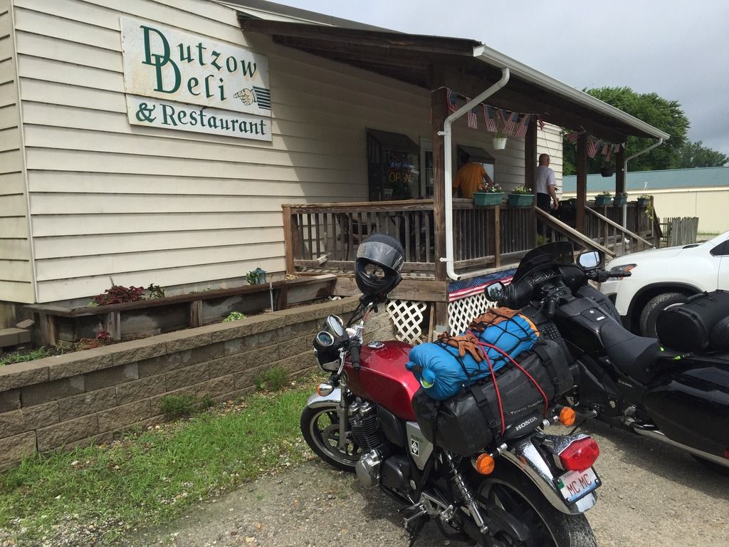
If you have a chance sometime, go look at another picture of me where you can see my gloves. When they're dry, they're light tan, almost yellow.
[url=http://s1318.photobucket.com/user/emptysea43/media/Ozark%20Mountain%20Daredevils/6E9B7EF4-61DE-4D27-8668-0F33599174CB_zps9yciy78k.jpg.html]

The truly wet portion of our ride along the Missouri River on MO94 was over. We made decent time the rest of the way to Jeff City, where we gassed up, snacked up, and figured out where to go next. It was plenty hot by this point, but heat is infinitely better than wet. I loved this entire stretch of road, from St. Charles to Jefferson City. Nothing too technical, but plenty of sweeping turns and some elevation changes as well. There is one fairly straight stretch where we were riding along what I think is part of the Missouri River flood plain with small, tree-covered mounds to our right and flat farm fields and, eventually, the river to our left. I recall looking over the plain and seeing the Missouri State House poking its domed head above the horizon from the other side of the river. If you're in the area, ride MO94. Just choose a dry day and maybe do it early enough to avoid heat and traffic. Glen was dead on right when he picked this road.

A note on tires, rain, and the CB1100: My 2013 CB1100 was fitted with new Michelin Road Pilot 3 tires about 8500 miles before this trip. As uncomfortable as I was with my rain-filled boots, my foggy visor, and my water-weighted riding garb, I was never unsure of what my bike was going to do. The bike and tires did their job admirably and I always felt secure, even at the height of my angst over the situation.

[Author's note: My apologies for the delays between updates. Work and a few technology issues (Photobucket locks up my browser sometimes) have kept me from posting more quickly.]
 
Great stuff as always Sea. I like the interjection of the music, the humor and the philosophy in the ride report. Wish I had the talent.
 
Excellent work, MTC. I confess I was a little surprised not to hear you singing that old Nancy Sinatra standard, These boots are full of water.
 
Thread starter
More to this story coming soon. It's just too difficult to post long posts with pictures from this old iPad and I'm too busy actually working when I'm at my work PC.
 
I'm having a great time reading this because it reminds me of a trip to Eureka Springs in the late 2000's where were encountered the same kind of rain, hail, tornados.

I went to college in Springfield, MO and know the roads down that way quite well. Looking forward to the next installment of your story. You, sir, have more than earned the title "Bard".
 
Thread starter
Ctatyk_imp said:
I'm having a great time reading this because it reminds me of a trip to Eureka Springs in the late 2000's where were encountered the same kind of rain, hail, tornados.

I went to college in Springfield, MO and know the roads down that way quite well. Looking forward to the next installment of your story. You, sir, have more than earned the title "Bard".
Most establishments have given me the title "Barred", but thanks :)
 
Thread starter
Day 2: St. Charles, MO to Springfield, MO via Jeff City (continued after a rain delay)

14 June 2015

I wonder if residents of Jefferson City cringe a little at "Jeff City" like I do at "Chi Town". We didn't hang around long enough for me to ask anyone; just gas, water, a couple of Bulls Eyes, and go.

By the time we crossed the Missouri River on US54 into Jefferson City, our fear of rain was replaced with the realization that summer in Missouri can be every bit as soggy now as it was back when Tom and Huck were having their adventures here a century and a half ago. Plenty hot enough that I think I could have sprouted ferns inside my (still damp from the morning rain) helmet.

We found a Phillips 66 station and stopped for gas. The afternoon sun was at such an angle that the awning over the station's door provided only a tiny sliver of shade for us while we hydrated and consumed a few road snacks.

A note about road snacks:

My ADV friends seem to snack on granola or trail mix on their rides. My cruiser friends seem to prefer beer nuts. My closest riding friends, though, like Bulls Eyes. You know, those caramel rings with the marshmallow cream centers, individually wrapped in plastic? Yeah, those. I think Glen started bringing them on rides and they caught on in a big way. Either Laura or Glen has a big bag of them on their bike for every trip. They have a long shelf life (half life?), don't melt or dry out, and are pretty tasty. I recommend them highly.

After our delicious lunch of Bulls Eyes and water in the sliver of shade in front of the Phillips 66, we were on our way to Springfield and the Clarion Inn and Suites.

Because of our protracted stop in downtown Dutzow and the precipitation which precipitated it, we were anxious to get to our hotel and relax. The route for this last leg of the day was US54 to MO5 to I44 to US65 to Battlefield Road to the Clarion Inn & Suites. Easy route, a mix of 2, 4, and 6+ laned roads, and enough speed to keep us somewhat more comfortable than the concrete slab at the gas station. As I recall, Glen changed to this route from a more scenic one while munching on Bulls Eyes at the Phillips 66.

Nothing much to report on about this route except that I did get the sense that we were approaching or riding through a recreational area -- more motorhomes, boats on trailers, brown road signs, and the like along US54. Upon later review, I discovered that we had passed over and astride Lake of the Ozarks, one of the prime vacation attractions in that part of the U.S. The lake is a reservoir created with the construction of the Basnell Dam in August of 1929. The hydroelectric dam impounded the Osage River and filled the 54,000 acre lake. Lake of the Ozarks has 1150 miles of shoreline on which are perched over 70,000 homes, mainly vacation homes, which house some of the 5,000,000 folks that visit the lake each and every year. One would think that I would have had more than "a sense" that we were in a recreational area. Well, it was hot, ya know.

Our motel was located on Battlefield Rd. just off of US65 in Springfield. The exit ramp off 65 and the overpass portion of Battlefield were under major reconstruction. There were cones and other temporary traffic markers sending us into what I swore was the oncoming lane of traffic. It was messed up, man. I recall questioning the sanity of the engineer who designed this temporary maze. As it turns out, we had stumbled upon my first Diverging Diamond Interchange. Who knew? I didn't...until months later.

A Diverging Diamond Interchange is designed to move traffic smoothly and more safely by swapping the lanes on the bridge to the opposite of their traditional configuration (left to right, right to left). The first DDI in the U.S. was built in Springfield, MO in 2009. The Battlefield interchange was one of several more built since. It was only months later, while driving on my first (completed) DDI in the Chicago suburbs, that I realized what all the crazy traffic markings were on Battlefield Rd. I'm sure that all the well-traveled readers of this report have driven or ridden on a DDI, but if you haven't, keep your wits about you the first time and just enjoy the flow on all the future encounters. I do not understand why this engineering masterpiece has not been in place all over the world since the invention of concrete roadbeds. Diverging diamond interchange - Wikipedia
http://www.divergingdiamond.com/history.html

Sunday night at the Clarion was shaping up to be a pretty dull affair. The hotel was nice enough, but it was located in a commercial area with not many decent dining choices within walking distance. Oddly enough, the only restaurant open was Flo...


Flo was a nice little place serving a variety of Asian cuisine, with a focus on sushi. Mike A and Judy did not join us for dinner as they rode to visit a friend or relative (I can't recall which) who lived somewhere in or near Springfield. The remaining five of us had a lovely dinner. It was here, I believe, that Laura first referred to Mike G. and me as "Gin Snobs" because we had an extensive gin-related conversation with our server, Troy or Trent or Trevor or something. I suggested that we would prefer the title "Juniperist" to which Laura countered that that was only more proof that we were Gin Snobs. Her title has stuck and Mike and I much prefer "Gin Snob" to another title given to us, "Two and two?", the origin of which is will be revealed in an upcoming report of our trip to Michigan last spring...if then. I may have to save that story for the next rally.

Oh, and for those interested, I believe that I had a Hendrick's martini with a twist and Mike had a Bombay Dry with olives.

Once again, the management of our hotel allowed us under-canopy parking which was a good thing because a pretty significant storm was coming our way. We worried for Mike and Judy out at night on not-so-familiar roads in a storm, but they arrived back safely ahead of the storm. It turns out that the person they were visiting lived about a mile from our hotel.

We slept well. The rooms were clean and quiet. We were close to the highway, but not so close that we heard traffic. We were glad to be well-rested for the next leg. Next stop, Eureka Springs!

End of (a long) Day 2.
 
Thread starter
Day 3: Springfield, MO to and in Eureka Springs

15 June 2015

Short ride this day, but pretty. It's only about 80 miles from Springfield to Eureka Springs which was nice because our plan was to hang out in this crazy little town for the afternoon. I suppose you may, upon reading future installments of this log, come to the conclusion that we would have been better off spending the day riding, but a short ride to spend an afternoon in a historic little town seemed to be the right choice at the time.

Native Americans came to what is now the Eureka Springs area for the healing powers of the spring water. Dr. Alva Jackson is believed to be the first white person to locate Basin Spring. He claimed that the waters cured eye ailments. During the American Civil War, he established a hospital in a cave near the spring and treated his patients there. After the war, Judge J.B. Saunders encouraged his friends to come to the area, claiming that the spring waters had cured him of his own ailments and the city of Eureka Springs was effectively born.

The town became and has remained a tourist and retirement destination since the late 19th century. It is surprisingly culturally diverse, with a thriving art and music community, including opera, blues, bluegrass and of course Southern rock. In 1967 a 7 story statue of Jesus Christ was built and serves as kind of a mecca to Christians in the area all year around, but especially during Easter season. Also in the 60's, Eureka Springs became something of a mecca for hippie artists and they and their free-love offspring have remained a significant segment of the community. Eureka Springs was the first city in Arkansas to issue a marriage license to a same sex couple. Pretty interesting demographic mix, I think.

The town center is set in the bottom of a valley with buildings and streets built up along the valley walls. The streets gave me the feeling of walking along a switchback path into or out of a canyon. There are at least two flights of concrete steps which allow steep shortcuts between the switchbacks.

13 86 23

There were a few more roads involved, but Glen's route for the day was MO13 to MO86 to AR23. Funny thing that we learned about Glen on this trip: he memorizes the route numbers by matching them to athlete's jersey numbers. In particular, Chicago Cubs, Bulls and Blackhawk players' jersey numbers. That he uses this mnemonic device is not as fascinating as his ability to recollect sometimes obscure players' numbers. I don't recall the exact players he used for this route, but he would say something like this "OK, so it's Johnny Knox to Zach Miller to Ryne Sandburg." In Wisconsin and Missouri, on their alphabetically named roads, he uses player's initials, "Avellini to Zobrist to Dan Hampton."


This route proved very enjoyable, if not particularly challenging. The Missouri portion was just typical country roads, but there were several elevation changes and we crossed Table Rock Lake on a steel trussed bridge. I almost always like riding across bridges. I suppose it's akin to my enjoyment of taking my bike on a ferry. As my Ferret-Cam was long since discarded due to excessive moisture (was that only the day before?), I do not have road pictures.

When we got close to turning off of Zach Miller and onto Ryne Sandberg, the road that would take us into Eureka Springs, Glen stopped for gas and he suggested that Mike G and I take off and meet them in town. He had read that this section of AR23 was a good place to get to +10 or so and he would bring up the rear with our "+5 is all I care to do" contingent. He was right. Mike and I thoroughly enjoyed our few minutes of freedom on this beautiful stretch of road. We stopped at the historic Eureka Springs & North Arkansas railway station on the outskirts of town and waited for the rest to catch up. The ES&NA station was closed when we were there, but they apparently offer train rides, some of which include dining in their restored dining car. Something to do next time I'm in the area.

Assuming that our compatriots rode at +5, the time we waited for them at the station might lead one to believe that Mike and I possibly broke the +10 barrier from time to time. He and I contend, however, that the others were slowed by other traffic and probably were traveling at or below the posted speed limit. That's our contention and there is no evidence to the contrary.

We regrouped at the station and Glen lead us into town. Because of the steep streets, it was pretty much a given that we would park on the floor of the valley, but not knowing the lay of the land, it took us a couple of circuits to figure that out. Ultimately, we found a pay lot which the cheapskates in our group didn't love, but since they allowed multiple bikes in each spot, it worked out just fine.

Parked!
[url=http://s1318.photobucket.com/user/emptysea43/media/Ozark%20Mountain%20Daredevils/E430188B-AE91-46C4-ADDF-94CB6C3546D6_zpszlzci3nd.jpg.html]

Since we were going to be in town for the afternoon, it seemed appropriate to start our visit off with a cold beer. It was probably in the upper 80s by this time and humid. A beer would hit the spot and we'd have hours before we were back on the bikes. As luck, and probably some planning on the part of the local chamber of commerce, would have it, there was a bar directly across from the pay parking lot. To this day, I'm not sure if The Cathouse Lounge is the "pub" part of Pied Piper Pub & Inn or if there are two bars in the building. Everything was connected by a common front porch , so it was hard for me to tell. It didn't matter much, though, since the cold beer tasted great on the hot front porch.

Cathouse Lounge?
[url=http://s1318.photobucket.com/user/emptysea43/media/Ozark%20Mountain%20Daredevils/EDECA108-39B9-4AB2-B03F-23E7A1B76BF8_zpsxwzpjeyl.jpg.html]

or Pied Piper Pub & Inn?
[url=http://s1318.photobucket.com/user/emptysea43/media/Ozark%20Mountain%20Daredevils/87312480-3FEE-49F7-A39F-851D5CD2164F_zpsommp712r.jpg.html]

Like I said, the porch was hot.
[url=http://s1318.photobucket.com/user/emptysea43/media/Ozark%20Mountain%20Daredevils/E301E261-4481-4440-B33D-FC0B03BFE837_zpsekfxwpj3.jpg.html]

They really do have healing waters in Eureka Springs.
[url=http://s1318.photobucket.com/user/emptysea43/media/Ozark%20Mountain%20Daredevils/0470FFF9-4DB0-48F7-A0E0-F2EDB0F27113_zpsfxoghes5.jpg.html]

We had lunch at the Eureka Grill which is is tucked into the upper corner of the downtown area. They have a nice porch there, too, which gives a sliver of a view of the hills beyond. Stupidly did not take pictures here. Great sandwiches and just a great place to sit and rest from our hike up the "switchbacks".

The rest of the afternoon was spent shopping, sightseeing, and generally being goofy.

I call these the "Hippie Stairs", but they probably have a real name. I was gassed by the time I got to the top.
[url=http://s1318.photobucket.com/user/emptysea43/media/Ozark%20Mountain%20Daredevils/214449AE-C3F7-424F-9AAF-AC2D50994874_zpsc4ldqhsn.jpg.html]

Prisoners? Glen and I sent this picture to folks back home to let them know that we were behaving ourselves.
[url=http://s1318.photobucket.com/user/emptysea43/media/Ozark%20Mountain%20Daredevils/8AD98620-9E14-41B2-A46C-6F3DB4D4251E_zpsge3umpi9.jpg.html]

After lunch, and some more shopping (the cigar store also sold bongs, by the way...I didn't buy either), we headed back to our bikes. We just had two miles to ride to the Trails Inn and it was plenty hot out by now. Some of us decided to stow our jackets (and riding pants in my case) and we cruised through the remainder of the town and on to the hotel in jeans, t-shirts, and helmets. Not something I recommend or condemn, but it felt good and odd all at the same time.

Checked into the pool...err...the hotel and got the bikes set for the night. Reconvened poolside to cool off. Cooling off in the pool was easily the best end-of-ride activity I've had on any trip I've taken.

After showers and clothing changes, we headed on foot down the road for dinner. Along the way was this odd little place called Motorcycle Supply Company. Inside was all manner of bike parts, mostly for older bikes. Kind of a dingy place, but cool, too. I think the guy said he was selling out, but maybe I'm wrong on that. I'd definitely stop in again, if it's still there, just to nose around the parts bins.

He had a few bikes inside the shop...
Motorcycle Supply
[url=http://s1318.photobucket.com/user/emptysea43/media/Ozark%20Mountain%20Daredevils/DE9CAC44-28AF-4BBA-A4FA-84F7A0A3267C_zpsdumsiwvx.jpg.html]

Outside Motorcycle Supply was this bike with a very fit looking rider in all black gear (Klim, if I recall). He wouldn't tell us his name, or let us take is picture. He was quite adamant about it and it wasn't like we even asked him about the pictures. He was cordial, but very vague about where he was going, where he was from, or really anything that even skirted on the personal. We decided he was CIA or possibly an assassin, maybe even a CIA assassin. Nice bike, though.

KTM Spy Bike
[url=http://s1318.photobucket.com/user/emptysea43/media/Ozark%20Mountain%20Daredevils/D2A780CD-3A88-4ED8-8E5B-DF04A6207FB1_zpsdt6adcdp.jpg.html]

Dinner was at the Rockin' Pig Saloon. We got there just in time to watch the puck drop on the Blackhawks Stanley Cup Finals game. The folks there were good enough to keep their place open until the game ended; with another Stanley Cup being hoisted by the Hawks.

In between the puck drop and cup lift was an amazing dinner with a wide variety of craft beers to accompany it. A few of us got the ribs. Biggest slab of ribs I've ever seen since watching the opening scene of The Flinstones when I was a kid. Just a fantastic dinner with fantastic people.

Rockin' Pig Mike and Judy
[url=http://s1318.photobucket.com/user/emptysea43/media/Ozark%20Mountain%20Daredevils/C50F6AE8-B71C-4D63-B48F-030F5D3A8782_zpsvlrzwrzy.jpg.html]

Rockin' Pig Matt and Cheryl
[url=http://s1318.photobucket.com/user/emptysea43/media/Ozark%20Mountain%20Daredevils/A2711F6E-3394-4723-9270-A21EA4797D4D_zps2n6ejnfq.jpg.html]

Rockin' Pig Ribs - Two Plates=One Serving
[url=http://s1318.photobucket.com/user/emptysea43/media/Ozark%20Mountain%20Daredevils/1D5087F8-F149-423F-BA61-C8586BC2FDED_zps7r0qjujh.jpg.html]

We walked home, exhausted but ecstatic. Not surprisingly it rained overnight, but it had cleared nicely by the time we returned from breakfast, also just a short walk across the road. Incidentally, the hotel was great, except for the "continental breakfast", which kind of sucked.

The Trails Inn - pool view.
[url=http://s1318.photobucket.com/user/emptysea43/media/Ozark%20Mountain%20Daredevils/359B8C9B-199A-4A53-B119-122BF028D810_zps38hadgaf.jpg.html]

Headed out on AR23 to get to Harrison. If you look at a map, you will see that AR23 does not go to Harrison. If you're a motorcyclist, you will understand.

End of Day 3
 
More excellent stuff, MTC. Looking forward to more of it.
 
Yep great stuff. Good to see the gang again.
 
Thread starter
Inhouse Bob_imp said:
So, that's a spy photo of a spy bike, is that right?
:thumbsup:
LOL..maybe, but we thought it odd that he'd let us take a picture of his bike, but not him. Maybe there's some kind of secret scan code on the bike that allows him to track an iPhone on which a picture of it was saved. This is why I have my wife start my car each morning. ;)
 
Thread starter
Day 4 - Eureka Springs, AR to Harrison, AR

16 June 2015

"Floatin' down that old river boy, leaves me feelin' good inside,
Floatin' down that old river boy, tryin' to get to the other side,
Yesterday is slowly fadin',
I been waitin', now forever, for this ride.

Ride the river in this boat, ride the river.
Ride the river in this boat, ride the river." - from the aptly named JJ Cale/Eric Clapton song "Ride the River"

Laura walked out of The Trail's Inn office and said to those of us walking in for the complimentary breakfast, "Don't bother". I peaked in anyway, and found on the small check-in counter three dispenser bins filled with dried cereal, a coffee urn, a selection of foil-covered plastic juice cups, and a few sweet rolls wrapped in cellophane. I shouldn't have bothered. Fortunately, there was a nice little diner across the way. Not much to look at, really. Just a free standing sign-on-a-post in front with the unambitious name "Pancake's Place Family Restaurant" printed in brown letters against a translucent yellow, though some may say gold, plastic background. Over the door and against the white frame building was another sign, this time in painted wood, announcing "Pancakes + Waffles". Adjacent to this sign was, inexplicably, a plastic actual size replica of the front end of a red 1959 Studebaker Lark tacked flat to the wall at a racy 45-degree angle. The food was good. In an ironic twist, the breakfast buffet option had neither pancakes nor waffles. They had eggs and some sides, though, and I think that, for the two of us, with tip, it was $10.00. Maybe $12. Didn't ask if they had tea.

A side note about ride planning: Glen likes to have buy-in from the other riders on routes he plans. I'm the same way. I think he does this to be more inclusive. I do it because it tends to keep the post-ride griping to a minimum.

Laura had arranged for us to kayak on the Buffalo River this day on our way to Harrison. The Buffalo Outdoor Center was all set for us, but Tropical Storm Bill and the monsoonal-style storms hammering the area for the past week or more meant that river levels were unusually high. High water is generally fast water and it was highly unlikely that we were going to ride the river. However, the outfitter's rules were that we would only get our deposit back if the river conditions were prohibitive. Since we had to leave Eureka Springs before they opened in order to make our reservation time, we decided to ride to the outfitter. If we were lucky, we'd be able to kayak. If not, we'd get the deposit back.

The morning's route, which Glen proposed to us at breakfast, was designed as a fun way to take us to Ponca, AR where the outfitter was located. His plan was basically Michael Jordan to Steve Fuller/Kyle Schwarber to Leslie Frazier to Jim Dooley (23 to 412 to 21 to 43) and taking Jose Cardenal/Walt Harris (127) as a short cut between 23 and 412. That was the plan as I recall it. Until the road closures, detours, and standing water changed them.

Route (I think) 23-412-21-43


The roads where beautiful. This part of Arkansas is very hilly, not exactly what I'd call mountainous even though the rivers and roads are carved through forested limestone mountains. A little south of where we were riding is a 19 mile stretch of AR23 named "Pig Tail Scenic Byway" which we planned to ride the following day. The section of AR23 north of the Pig Trail has plenty to offer for the motorcyclist except for the porcine name. Well paved. Plenty of curves. Lots of elevation changes. Forests. Farmland. Rivers. It was hard to imagine that the Pig Trail could be any more pretty than this.

As we rode along our 50 mile or so route, the sun came out in earnest and we, or at least I, began to speculate that we may actually get to kayak on the Buffalo River after all. However, those thoughts left almost as quickly as they came as we started to encounter work crews pushing mud off the road with bulldozers and creeks swelling to the very tops of the bridges over which we crossed them. Some of the swelling could not be contained and we were detoured around at least one crossing, maybe more. When we were very close to the Buffalo Outdoor Center, reddish-brown mud crossed the entire roadbed and we took our bikes through a long, slippery puddle to get to our destination. The water wasn't too deep, a few inches below the bottoms of my pegs, but deep enough to put a decent rooster tail up behind each bike. I was riding sweep and remember wishing my camera on a lanyard still worked. This was, and probably will be, the closest this crew ever comes to "off-road" riding.

Dry Docked
[url=http://s1318.photobucket.com/user/emptysea43/media/Ozark%20Mountain%20Daredevils/789FFFF7-A510-4B14-8291-A4A17009780D_zpsbrbhdmnb.jpg.html]

Dirty Bike #1
[url=http://s1318.photobucket.com/user/emptysea43/media/Ozark%20Mountain%20Daredevils/865305E6-450E-4E15-9739-D0ADF7339114_zpsdvzadnqj.jpg.html]

Dirty Bike #2
[url=http://s1318.photobucket.com/user/emptysea43/media/Ozark%20Mountain%20Daredevils/C24BB6CA-EBE0-4080-994D-2F5DA464D2D6_zps6rbtwbtc.jpg.html]

Well, we arrived at the outfitters and our trip was indeed cancelled due to the speed and height of the river. We hung out in their very nicely appointed shop and showroom for awhile and then turned our attention and our bikes north and a little east to Harrison.

(Day 4 to be continued...)
 
Thread starter
There was enough of a WiFi signal to check our weather apps and the forecast for the area was for, surprise, rain coming in in mid to late afternoon. After pricing out some canoes, kayaks, and rafts solely because there is not much else to do at the BOC if one isn't actually canoeing, kayaking, or rafting, we decided to head to Harrison.

Harrison is only about 50 miles or so from Ponca and the Buffalo Outdoor Center, but we would be on state roads and, on the advice of one of the BOC staff, we decided to grab lunch in the town of Jasper, Arkansas. The combination of back roads and a lunch stop would, we reckoned, put us into our hotel in Harrison a little before the afternoon storms would roll in.

Buffalo Outdoor Center to The Ozark Cafe'


There's really only one route from Ponca to Jasper and that is AR-74 (Jimbo Covert to those interested our mnemonic methods). 74 is a terrific stretch of road. A curvy ribbon of asphalt that crosses over a 2000 foot high ridge before dropping over 1000 feet into the little town of Jasper. We had traveled over many roads on this trip; some historic, some scenic, many wet, but this was the first road that really gave us what we we had been anticipating since we started planning this trip so many months before.

Alas, another day without Ferret-Cam. As I write this over a year after the events, I am suddenly puzzled as to why I didn't stop at a Walmart and buy a new camera. I guess that's all water under the Cordura at this point. I snipped the next two pictures from Google Street View and I hope they provide some understanding into why I enjoyed this leg of our trip so much.

AR74-1
[url=http://s1318.photobucket.com/user/emptysea43/media/Ozark%20Mountain%20Daredevils/AR74-1_zpsyff5h1mo.jpg.html]

AR74-2
[url=http://s1318.photobucket.com/user/emptysea43/media/Ozark%20Mountain%20Daredevils/AR74-2_zpsuoidwahn.jpg.html]

We parked in front of Emma's Museum of Junk in beautiful downtown Jasper. I think Emma was out for lunch, because the store was locked, but there were some items still on display in front of it. Either that or Emma was out TO lunch and just forgot to bring some of her junk inside. Either way, we didn't go into the 'museum' but it might be a fun place to check out sometime in the future.

Jasper's main drag reminded me of a mining town in Colorado or maybe Alaska. We didn't stay long enough to fully explore it, but I liked what I saw of it.

Mike G. checking out Emma's junk. Jasper, AR
[url=http://s1318.photobucket.com/user/emptysea43/media/Ozark%20Mountain%20Daredevils/19C65365-BA19-4780-8B5E-BAC78564831B_zpsxyjtq9te.jpg.html]

Our destination was The Ozark Cafe'. It's a neat little diner with a menu that ranged from biscuits and gravy to burgers to quesadillas to ice cream. One difference between Ozark Cafe' and most mid-western diners is that they are also a music venue. There was not a band playing on a Monday at noon (go figure), but there were handbills advertising a variety of musical performances throughout the month.

I liked the decor. It reminded me of a cross between an old-time service station and a boathouse -- with a little blues bar tossed in.

Ozark Cafe' Jasper, AR Outside
[url=http://s1318.photobucket.com/user/emptysea43/media/Ozark%20Mountain%20Daredevils/758763AF-5487-4FA4-BCDD-F07BB48EE064_zpsjynnnhxd.jpg.html]

Ozark Cafe' Inside
[url=http://s1318.photobucket.com/user/emptysea43/media/Ozark%20Mountain%20Daredevils/2428BC60-4D4E-4F6E-94FA-07561D03EE1E_zps4xexdnbu.jpg.html]

My recollection is that it had been sunny and hot for most of our ride from Eureka Springs to the outdoor center and partly cloudy and hot for our short trip into Jasper. As we left Jasper, though, it was definitely cloudy. The clouds didn't seem to settle the heat down, though.

Only a couple of ways to get from Jasper to Harrison and AR7 (Bob Avellini or Rick Monday, take your pick) was the route Glen chose. Nice choice. Very curvy on the way out of Jasper then straightening out near the end of the 30 some-odd miles into Harrison. A little challenging, but not dangerously so, at the beginning with a nice comfortable "cool down" stretch to our hotel. 74 and 7 make Jasper, AR a pretty worthwhile destination for any motorcyclist touring the area.

Ozark Cafe to Hotel Seville
[url=http://s1318.photobucket.com/user/emptysea43/media/Ozark%20Mountain%20Daredevils/Jasper%20to%20Harrison_zpsmmfwaltg.jpg.html]

Another road picture courtesy of Google. This time AR7
[url=http://s1318.photobucket.com/user/emptysea43/media/Ozark%20Mountain%20Daredevils/AR7_zpsrmkb3cgv.jpg.html]

Our arrival at our hotel was a little earlier in the day than we had originally planned, but the cancelled kayak trip afforded us the opportunity to beat the rain to our hotel. We probably could have planned a longer route for the afternoon, but it turned out that our plan to just barely beat the rain worked perfectly (for the one and only time all week, by the way).

The Hotel Seville in Harrison is one of the most remarkable properties at which I have ever stayed. Here we were in the middle of Arkansas in a fairly small town and, in the middle of what seemed to be the industrial section of it, stands a Spanish-Moroccan styled boutique hotel that was built in 1929. Recently renovated, the hotel features small, but very well finished rooms, underground parking, a quiet and comfortable bar, and an amazing lobby. Our plan was to stay at the Hotel Seville for three nights and it felt like it was going to be the most luxurious base camp of any motorcycle trip I've ever taken.

We got the bikes parked, checked in, and off-loaded our gear. It was time to shower and relax for a bit before reconvening in the lobby to plan our next meal and the next day's ride.

Underground parking and civilized unloading of gear
[url=http://s1318.photobucket.com/user/emptysea43/media/Ozark%20Mountain%20Daredevils/FA5376E6-F6EC-4A6B-B792-C6308BA9A476_zpshoaw6tsq.jpg.html]

I showered, unpacked, checked in with work, and headed down to wander around the hotel. It had already started raining pretty heavily by this time. We talked to another group that was mostly couples on big Harleys (maybe one Goldwing). They talked about a particular road they had been on that day that was not to be missed. Either Glen or I wrote it down, but circumstances would prevent us from exploring it.

Underground Parked. Note the rain in the street beyond.
[url=http://s1318.photobucket.com/user/emptysea43/media/Ozark%20Mountain%20Daredevils/FBA99B16-F1C5-4C01-B300-4441E15FAA1F_zps0glu9ekp.jpg.html]

Comfy inside this piazza of a lobby.
[url=http://s1318.photobucket.com/user/emptysea43/media/Ozark%20Mountain%20Daredevils/47D925F9-29B9-4A43-83BA-7E625AA77147_zpskskvdqiu.jpg.html]

The hotel has a space just outside the garage where one could wash one's motorcycle. I know that Mike A. washed down his Goldwing and I think I washed the CB1100, but I can't recall. It didn't matter in the end, though, because the rain continued to pelt our bikes and rewrite our route maps for the rest of the week.

Dirty Bike #3 - Hotel Seville, Harrison, AR
[url=http://s1318.photobucket.com/user/emptysea43/media/Ozark%20Mountain%20Daredevils/0939932E-0DCF-4AC8-B8AA-627F4BA0A6BD_zpsepztn6ll.jpg.html]

We met in the bar and it was just our group and the bartender for most of the night. She helped us order pizzas from a local joint, mixed a very competent martini, and was just the right amount of attentive.

I seem to recall that it was over pizza and drinks that we decided to shorten our stay at this lovely hotel by one night. Hurricane Bill had already made land and was arching it's way toward us as a tropical storm. We did not like the looks of the path-probability cone as it had Harrison in the dark purple "high percentage" area. It looked like the next day would be OK, though, so we thought we could get a day's worth of riding in, spend the night in Harrison and head north the following day. We went to sleep thinking that was the plan, but we were dreaming.

End of Day 4
 
Back
Top