GOOGLE MAPS

Thread starter
Stichill_imp said:
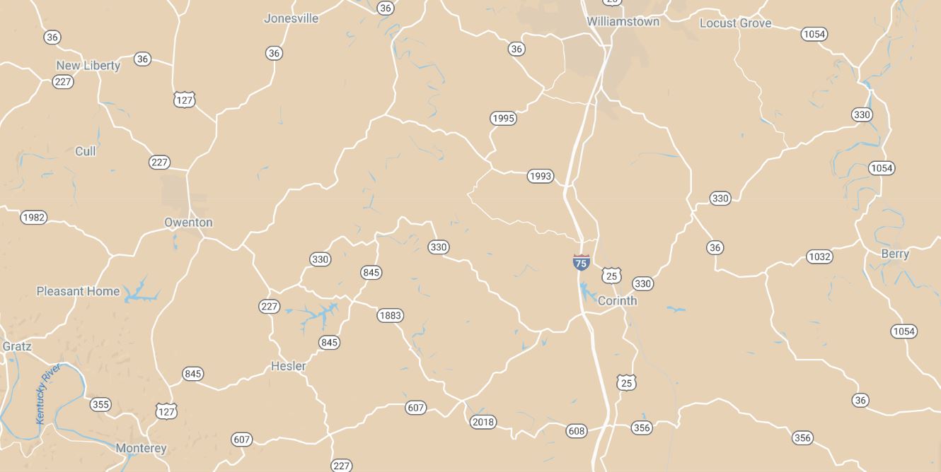
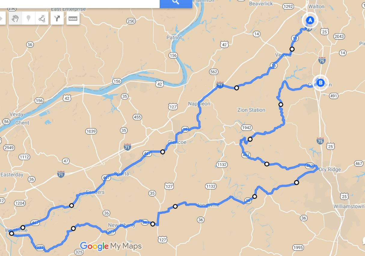
Here's a trick: in Google My Maps, change the base map from "Map" to "Simple Atlas" to better highlight available secondary roads.

"Map"
541aaae0efef11d57cf862c42f4737a8.jpg


"Simple Atlas"
e57d6cb234796c4f50ee22de42f66c8e.jpg
WOW! Look at all those wiggly roads. You're a lucky guy Stitch.

I takes me an hour or more to reach the real wiggly roads I like to ride. But even my quiet roads from and to home are carefully chosen to avoid traffic, provide a bit of scenery, and ride enthusiastically.

I find it a lot less stressful to preplan using Google Maps to find the motorcycle friendly roads, than wander around aimlessly looking for interesting roads, good restaurants and gas stations.

Google Maps also helps to pass the winter searching for new roads to ride and explore.
Stichill_imp said:
Google My Maps is completely different (and more powerful) than Google Maps. You'll need a Google account to get the most out of it, like saving your maps.

Try these links:
Sign in - Google Accounts
Thanks Stich!

Looks like I have a new toy for Christmas to play with.
 
Nortoon_imp said:
Stichill_imp said:
Here's a trick: in Google My Maps, change the base map from "Map" to "Simple Atlas" to better highlight available secondary roads.

"Map"
541aaae0efef11d57cf862c42f4737a8.jpg


"Simple Atlas"
e57d6cb234796c4f50ee22de42f66c8e.jpg
WOW! Look at all those wiggly roads. You're a lucky guy Stitch.

I takes me an hour or more to reach the real wiggly roads I like to ride. But even my quiet roads from and to home are carefully chosen to avoid traffic, provide a bit of scenery, and ride enthusiastically.

I find it a lot less stressful to preplan using Google Maps to find the motorcycle friendly roads, than wander around aimlessly looking for interesting roads, good restaurants and gas stations.

Google Maps also helps to pass the winter searching for new roads to ride and explore.
Stichill_imp said:
Google My Maps is completely different (and more powerful) than Google Maps. You'll need a Google account to get the most out of it, like saving your maps.

Try these links:
Sign in - Google Accounts
Thanks Stich!

Looks like I have a new toy for Christmas to play with.
The funny thing is that I lived here for 20 years before becoming a rider. I'm like a guy living in Hawaii for two decades who just realized he could go surfing out his front door. :)

Nortoon_imp said:
Stichill_imp said:
Here's a trick: in Google My Maps, change the base map from "Map" to "Simple Atlas" to better highlight available secondary roads.

"Map"
541aaae0efef11d57cf862c42f4737a8.jpg


"Simple Atlas"
e57d6cb234796c4f50ee22de42f66c8e.jpg
WOW! Look at all those wiggly roads. You're a lucky guy Stitch.

I takes me an hour or more to reach the real wiggly roads I like to ride. But even my quiet roads from and to home are carefully chosen to avoid traffic, provide a bit of scenery, and ride enthusiastically.

I find it a lot less stressful to preplan using Google Maps to find the motorcycle friendly roads, than wander around aimlessly looking for interesting roads, good restaurants and gas stations.

Google Maps also helps to pass the winter searching for new roads to ride and explore.
Stichill_imp said:
Google My Maps is completely different (and more powerful) than Google Maps. You'll need a Google account to get the most out of it, like saving your maps.

Try these links:
Sign in - Google Accounts
Thanks Stich!

Looks like I have a new toy for Christmas to play with.
Me too! Even though we have a lot of great riding around here, you still have to actively seek it out because the more modern intra-state highways have been built straight, on level grades blasted straight through the lovely Kentucky limestone hills. They are awfully boring to ride on but if you don't know better that's what you'll end up on around here.

Last January about this time of year I planned this local ride in Tyre to Travel and uploaded the waypoints to my TomTom Rider satnav/GPS. Then I hit "Record" and made a logfile of the ride, which I uploaded into Google My Maps as an archive of the fun I had; I rode 100 miles in a 12x12 mile square of Kentucky bluegrass country...absolutely hilarious! The people living on the connector roads were wondering who that nutcase was going back and forth for hours on end.


Nortoon_imp said:
Stichill_imp said:
WOW! Look at all those wiggly roads. You're a lucky guy Stitch.

I takes me an hour or more to reach the real wiggly roads I like to ride. But even my quiet roads from and to home are carefully chosen to avoid traffic, provide a bit of scenery, and ride enthusiastically.

I find it a lot less stressful to preplan using Google Maps to find the motorcycle friendly roads, than wander around aimlessly looking for interesting roads, good restaurants and gas stations.

Google Maps also helps to pass the winter searching for new roads to ride and explore.
Stichill_imp said:
Google My Maps is completely different (and more powerful) than Google Maps. You'll need a Google account to get the most out of it, like saving your maps.

Try these links:
[url=https://www.google.com/mymaps]https://www.google.com/mymaps
Nortoon_imp said:
Stichill_imp said:
Thanks Stich!

Looks like I have a new toy for Christmas to play with.
I think you'll have a lot of fun...great pastime for the winter doldrums! :thumbsup:
 
My Maps looks very interesting and I do have a Google account. THanks for the link! One question: Can I import an map from plain ol' Google Maps into the super-cool Google My Maps?
Nortoon_imp said:
Stichill_imp said:
Here's a trick: in Google My Maps, change the base map from "Map" to "Simple Atlas" to better highlight available secondary roads.

"Map"
541aaae0efef11d57cf862c42f4737a8.jpg


"Simple Atlas"
e57d6cb234796c4f50ee22de42f66c8e.jpg
WOW! Look at all those wiggly roads. You're a lucky guy Stitch.

I takes me an hour or more to reach the real wiggly roads I like to ride. But even my quiet roads from and to home are carefully chosen to avoid traffic, provide a bit of scenery, and ride enthusiastically.

I find it a lot less stressful to preplan using Google Maps to find the motorcycle friendly roads, than wander around aimlessly looking for interesting roads, good restaurants and gas stations.

Google Maps also helps to pass the winter searching for new roads to ride and explore.
Stichill_imp said:
Google My Maps is completely different (and more powerful) than Google Maps. You'll need a Google account to get the most out of it, like saving your maps.

Try these links:
Sign in - Google Accounts
Thanks Stich!

Looks like I have a new toy for Christmas to play with.
I have a very specific reason for wanting to use My Maps and those of you heading to Eureka Springs will see that reason in person. ;)
 
EmptySea_imp said:
My Maps looks very interesting and I do have a Google account. THanks for the link! One question: Can I import an map from plain ol' Google Maps into the super-cool Google My Maps?
Nortoon_imp said:
Stichill_imp said:
Here's a trick: in Google My Maps, change the base map from "Map" to "Simple Atlas" to better highlight available secondary roads.

"Map"
541aaae0efef11d57cf862c42f4737a8.jpg


"Simple Atlas"
e57d6cb234796c4f50ee22de42f66c8e.jpg
WOW! Look at all those wiggly roads. You're a lucky guy Stitch.

I takes me an hour or more to reach the real wiggly roads I like to ride. But even my quiet roads from and to home are carefully chosen to avoid traffic, provide a bit of scenery, and ride enthusiastically.

I find it a lot less stressful to preplan using Google Maps to find the motorcycle friendly roads, than wander around aimlessly looking for interesting roads, good restaurants and gas stations.

Google Maps also helps to pass the winter searching for new roads to ride and explore.
Stichill_imp said:
Google My Maps is completely different (and more powerful) than Google Maps. You'll need a Google account to get the most out of it, like saving your maps.

Try these links:
Sign in - Google Accounts
Thanks Stich!

Looks like I have a new toy for Christmas to play with.
I have a very specific reason for wanting to use My Maps and those of you heading to Eureka Springs will see that reason in person. ;)
I have not found a way to do that...it's strange but these two Google products seem to be developed independently of one another and run by different teams.

You can export from My Maps as an XML file and then use a converter to create other file formats, for example for a GPS. GPS Visualizer's GPS Babel is one that I've heard recommended, although as I've mentioned I use Tyre to Travel Pro which can import/export XML.
 
MTC, I've not found a way to import a Google Map into a MyMap either. You can now open a MyMap in the Google Maps app on your iDevice if you swing that way.

A couple of hints.
[li]I find using layer 1 as a place to store waypoints is a handy way to force the software to make my route go where I want it rather than the way Google wants it.[/li] [li]The default for MyMaps is that they are not shared. You can choose to share a view of your map or you can give permission to others to edit the map. That's handy for collaborative work.[/li] [li]There's a limit to the number of waypoints for each layer (10, maybe) and there's a limit of 10 layers per map. For multiple days' ride, a day per layer is not a bad practice.[/li] [li]However, the more data the map has to manage, the more likely the app is to crash. So, maybe, a day per map is a better way to go.[/li] [li]There's a bit of help for using it on the Interwebs.
[/li] Pretty much all the maps in my ride reports have been created in MyMaps. There's usually a link to the actual map in the report if you want to look to see what I've done. There's an example of one from this week here. You'll see I needed a couple of layers to fit in all the way points.

Stichill_imp said:
Thanks for that one Stichill. Looks handy
 
Good tips, Cormanus!

A trick I use to force the route to go the way I want is to place the waypoint along a road...not at an intersection. Placing waypoints at intersections gives the software (or, a GPS) more options to deviate from your intended route. But if the waypoint is located somewhere along every road you want to ride, it MUST take you down that road to reach the waypoint.
 
That's a good tip too Stichill! I try to do the same.

By exporting the MyMap to a .kml or .kmz file you can also load it into Google Earth and play with it there. I've not really played with Google earth lately, but I suspect it might be even more powerful than MyMaps.
 
So...i figured out how to import a map created in Google Maps into My Maps.....it's complicated as all get out and involves taking the original map's url and converting it to a gpx file then importing it as a layer in My Maps. I used a free site called GPS Visualizer to do the conversion and save the gpx file to my hard drive. i'm not yet proficient enough at this to explain it in more detail, but I will post more when I know more.

I like this option mainly because I understand how to work with Google Maps to create a route better than I do to create it in My Maps.
 
That's useful advice, MTC. Thanks.

You'll find creating a route in MyMaps pretty much the same as in Maps, although it is harder just to click somewhere on the map to create a waypoint.

If you have Google Earth installed on your computer, I suspect you could take every Google Map or MyMap of every ride you've ever recorded, convert them to .kml and then upload them all into Google Earth.

By the way, you can open a MyMap from within Maps. Click on the menu icon, select Your Places, select Maps and you should see a list of all your saved Maps. You can also select Create Map at the bottom of the screen to launch MyMaps.
 
Looks like a fun ride, Stichill.
 
That also looks like a fun ride, Django.
 
Django's ride puts my ride to utter and complete shame! The Alps are perhaps the greatest place to ride on the planet!
 
Thread starter
I was able to view it, but could not find a PRINT command.
I was able to use my PRINT SCREEN key to copy it to PAINT.
Then I was able to print and save it.

Unfortunately the big blue line obscures the road numbers.
Although there were points of interest (gas stations) there were no route directions.
 
Nortoon_imp said:
I was able to view it, but could not find a PRINT command.
I was able to use my PRINT SCREEN key to copy it to PAINT.
Then I was able to print and save it.

Unfortunately the big blue line obscures the road numbers.
Although there were points of interest (gas stations) there were no route directions.
Great feedback. Funny, but I didn't look for the text directions before posting as I was more interested in the look of the map. Kind of important to have the turn-by-turn in text format, at least for me. I'll have to figure that out. The printing problem is not a huge problem from my end since I will be creating a document using the map along with directions. Making the road numbers more visible is also a priority. Lastly, I only plotted gas stops on this map. I suppose I could add a layer which marked each road change, but I may run out of marks, plus I still don't know how to edit it. More to think about, I guess. Again, thanks for the great feedback.
 
Thread starter
I edit my ordinary Google Maps in PAINT.
I add large road numbers in white squares so I can see them with a quick glance.
The map also has the distance and estimated time printed.
I use the distances to calculate a fuel stop.
I use the times to calculate breakfast and lunch stops, and time home.

While Google Maps provides a hidden legend, I don't use it.
I paste my Google Map into WORD and write my own directions.
This is done by using STREET VIEW.
STREET VIEW lets me check to see if the route is worth riding.
I am looking for hills, curves, interesting scenery and paved roads.
It also lets me familiarize myself with the route.
That way I can add landmarks for turns, even if they are just stop signs.
If necessary I can add a small diagram or picture for tricky route changes.

It also lets me view restaurants I may consider stopping at.
Menus and prices can often be found using Google to search them out.

My 70 maps and reverse routes are parts of my day rides.
My maps only show from 1/2 hour to 2 hours of riding time.
That way there is much more detail shown.
I use them to move from selected points of food, gas, rest or interest.
They are shuffled like a deck of cards so I change the routes with every ride.

I looked at "My Google Maps" as it would be nice to share.
But the added complexity and limitations do not appeal to me.
I think I will stay with "GOOGLE MAPS" and just add to my deck.
 
I copied your map to my account so I could edit it. To change the route, first click on the route line. It will change to a lighter shade of blue with a white highlight. Then click on it again and hold the mouse button to drag it to a new road.

Edit: actually, this is very odd. The entire route moved as a unit, keeping the same geometry. On maps I've created, after I've clicked the route to highlight it, I then get a white circle as I hover over the route. I can click and hold to drag this white circle to a new position.
 
Stichill_imp said:
I copied your map to my account so I could edit it. To change the route, first click on the route line. It will change to a lighter shade of blue with a white highlight. Then click on it again and hold the mouse button to drag it to a new road.

Edit: actually, this is very odd. The entire route moved as a unit, keeping the same geometry. On maps I've created, after I've clicked the route to highlight it, I then get a white circle as I hover over the route. I can click and hold to drag this white circle to a new position.
I suspect that your editing issue is because I created the map in Google Maps then converted it to GPX before importing into MyMaps. I did it this way because it's MUCH easier to search for a location (in this case Shell gas stations along my route) in the regular version of Google Maps than it is in MyMaps. If I'm right, I think I will need to have my map 100% correct before exporting it to MyMaps, but maybe there's a work-around.
 
Back
Top